Wet boots and grey mouse
Thursday 8th February is a zero day in Hanmer Springs (meaning a zero kilometers day, in other words, we rested), between laundry, vegetables, fruits and hot pools. We met Arne again, but he has a bad pain to his leg, so bad that he actually decided to stop and rest for a while. One of the American girls, Maria, also have to stop for a health problem. The trail is sometimes a real strain for our bodies...


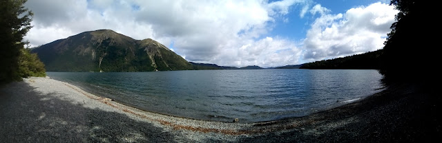
We follow the advice that 2 nice French people gave us yesterday and stay near the river to avoid the fallen trees on the official path. It saves us a lot of time and, cherry on the cake, the views on the Lake Sumner and the mountains are better from here.

Clouds get thicker hour after hour. The bad weather scheduled for tomorrow is on its way...
During the night, Marie-Laure wakes me up: she heard a sound in the plastic bags where we stock our food. I switch on the headlamp and move one of the bags. The poor frightened grey mouse that was hiding under hit jumps immediately in the opposite direction...on Marie-Laure's bed. She consequently screams in a very funny way considering the size of the animal, before laughing when she realizes the disproportion of her reaction. We laugh together for a while before going together to the pit toilets, located outside the hut. The rain didn't start yet.

When we wake up on Sunday morning, the rain welcomes us. Still, we decide to hike, as the trail notes does not mention any dangerous river crossing in case of rain. The only large river we need to cross today is bridged.
Till the pass, we're wet but it's ok. The path is now a small stream and our boots are soaked, but there is a bridge over the main river.
Things become complicated à little later, when the path makes us go through the riverbed... The river being quite high does not allow us to hike there anymore. We have to cross some streams and to scramble up the scree slopes to find a route that leads us down the valley.
I can't show you pictures of what we had to go through: our camera and the phone were deep down in our backpack, in order to avoid soaking them. But just imagine rushing rivers and shitty paths, boulders and bush, and no place where we could camp, every inch of floor being flooded. What a relief it was when we reached Locke Stream hut, where Elliot, the 'French Canadian hiker', had lighten a fire. We spent our afternoon and evening together, playing games and telling stories. Elliot also wrote us a small guidebook with all the places we should visit in May and June when we'll be in Canada.
 |
| A friendly bird that entertained us at least 20', hopping around us and even sometimes on us. |
But the reality is different. After a few kilometers, the trail becomes unmarked and sometimes even inexistent. We crawl through the bush (sometimes gorse), walk on the boulders of the riverbed and have to cross numerous rivers.
My back started hurting yesterday during a river crossing and the heavy boots, full of water, don't really help me. The trail can sometimes be really frustrating. By 5 PM, we reach a place from where we can try to cross a moderately wide river and join the road.

Here, there are markers in the forest, but as soon as we reach the Otira riverbed, we don't see any of them anymore. So we find our way through the boulders and the river forks and we somehow eventually manage to cross it and climb in the field on the other side.


After one night there, we buy a bus ticket to Christchurch for the next day. I also arrange an appointment with an osteopath in Christchurch, Arthur's Pass being a very small touristic village with only a few houses.
The next day's, we spent our time visiting Christchurch. The city was destroyed by an earthquake in 2011 that killed hundreds of people. They are now rebuilding it. It's a bit weird, but we learn to appreciate the place and the creativity deployed in the spaces left empty by the collapsed building : open air art, exhibitions, playgrounds,...


Comments
Post a Comment